WFS Access Locations
Projects using WFS can be accessed in the project namespace at https://paleocore.org/<project_abreviation>/wfs/.
For example
Navigating to the WFS page in a browser will show summary data for that project including the datasets that are accessible and the fields that are provided.
WFS endpoints are read-only and only authenticated users can view the WFS data.
Accessing WFS data through QGIS
This guide is for QGIS version 3.34 or later.
Access to WFS data requires logging in with authentication tokens instead of user name and password. Users can view their tokens in the user Dashboard.
To add WFS data to a QGIS project:
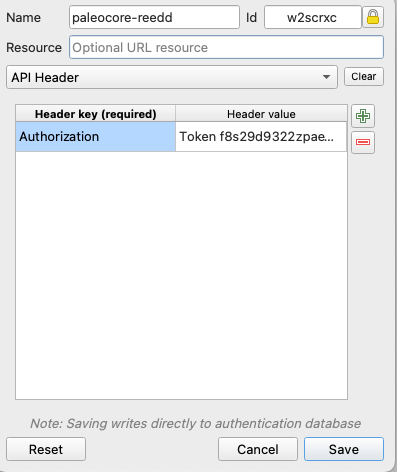
- Create a token authentication configuration in QGIS. In Preferences (MacOS) or Settings > Options (Windows) click the Authentication tab and then the plus button to create a new authentication configuration. Name the configuration, and select "API Header" from the configuration type drop down list.
- Click the plus button next to the header editing panel to add an API Header entry. Enter "Authorization" (without quotes) for the Header key, and "Token <user_token>" (without quotes and with your actual user token string) to the Header value column. The result should look something like the image below,
- In the map view add the data.
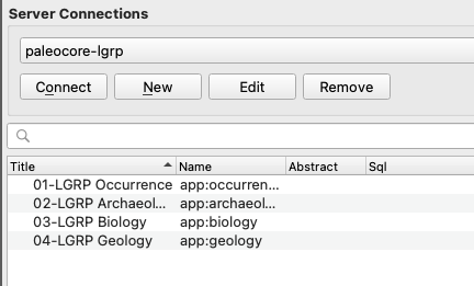
Layer > Add Layer > Add WFS / OGS API - Feature Layer ... - In the Server Connections window click New and edit the Connection Details. Provide a name and the url to the WFS endpoint, e.g. https://paleocore.org/hrp/wfs/.
- From the authentication drop down list choose the API Header authentication configuration created in step 1.
IMPORTANT: Under WFS options click "Ignore axis orientation".
WFS sends coordinates in the sequence set by the coordinate reference system. For EPSG 4326 (WGS 84 datum with geographic coordinates) the coordinates are in latitude, longitude. By checking the box to ignore axis orientation, WFS will send the coordinates in x,y sequence (longitude, latitude), which is the sequence QGIS expects. - With the Server Connection selected in the drop down, clicking Connect should cause QGIS to connect to the Paleo Core WFS server and to list the available datasets, like so,
- Select the layer(s) you wish to add and click the Add button on the bottom.
